Is a map a primary source?
A map can be both a primary and secondary source.
➡️ What is a secondary source?
➡️ What is the difference between primary and secondary sources?
If a map was produced as immediate evidence of an area, then it is a primary source. If the map is just a symbolic depiction of a space, then it is a secondary source. For example, maps of Hispaniola made by Columbus in the 1490s are primary sources, but a map created in 2005 showing Columbus' first conquered land is a secondary source.
A map that you made on a scrap of paper of the layout of a piece of land you saw can be used as a primary source.
- Columbus’s map of Hispaniola and your sketch are direct evidence of an area, hence primary sources.
- A sketch you made of an area you have not seen and the map of Columbus’ first conquered land made in 2005 are both not direct accounts of a surface, making them secondary sources.
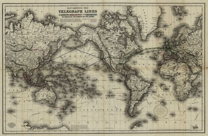
To illustrate further, the map below can be used as a primary source in a study about the development of telegraph lines between 1791 and 1872. Nevertheless, it would be classified as a secondary source in an analysis of maps of the world.
Frequently Asked Questions about maps as primary sources
🗺️ Is a map a secondary source?
A map can be a primary or secondary source. If a map was produced as immediate evidence of an area, then it is a primary source. If the map is just a symbolic depiction of a space, then it is a secondary source.
🚂 Is a railroad map a primary or secondary source?
A railroad map can be a primary or secondary source. If the railroad map was produced as immediate evidence of an area, then it is a primary source. If the map is just a symbolic depiction of a space, then it is a secondary source.
🧠 Is a mind map a primary source?
It depends on the scope of the research. If you were to research the way a particular brain organizes ideas, then the mind is a primary source.
🌎 Is a world map a primary source?
A world map can be a primary or secondary source. If the world map is contemporary and it is immediate evidence of the world's division, then it is a primary source. If the map is just a symbolic depiction of a space, then it is a secondary source.
🕯️ Is an ancient map a primary source?
It depends on the scope of the research. If you were to research the history of maps, then an ancient map is a primary source.